October 2024

Uluru

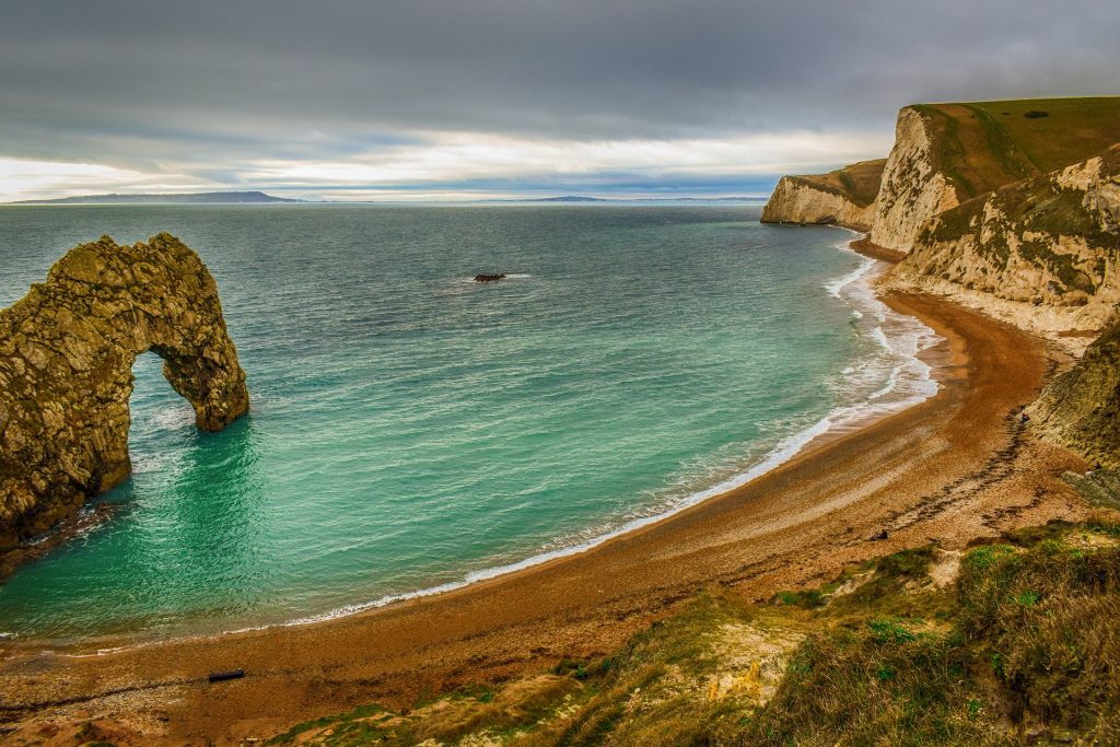
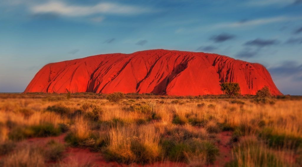
Uluru, (we will not be using the term ‘Ayers Rock’) is a sandstone monolith in the Northern Territory in Australia. It’s a geological wonder in its own right, but it’s also a cultural and spiritual icon for the indigenous Anangu people. This article explores the formation and geological characteristics of Uluru, its cultural importance, its troubled history with non-indigenous people, and the journey towards its return to indigenous ownership. How a monolith forms Uluru’s formation dates back 550 million years. During the late Neoproterozoic and early Cambrian periods, at this time life was just getting started with the world famous Cambrian explosion. The region was part of an inland sea. Over time, sediments were washed from land, through river systems, and found their way to this sea. Through the eons the relentless depositing of minute amounts of sand and gravel compressed into sandstone and conglomerate rock formations.  Around 400 million years ago, just as the first insects began to appear in the fossil record, tectonic activity began to shift these rock layers. The crust buckled and folded as two converging plates pushed relentlessly together, creating large folds and faults known as an inselberg or “island mountain.” Eventually, one of these inselbergs broke the surface and was exposed to the elements. This is how the great monolith came into being. If you look closely, you can still sort of make out the rock strata running diagonally down the face of Uluru as erosion has continued to weather away the softer rock Size and Shape Uluru is the second largest monolith in the world, behind Mount Augustus, also in Australia. It stands 348 meters (1,142 feet) high. Much like an iceberg, most of its bulk lies underground. It has a circumference of about 9.4 kilometers (5.8 miles). The rock is 2.2 kilometers (1.4 miles) long and 1.6 kilometers (1 mile) wide. Its surface is characterized by its deep grooves, ridges, and caves formed by erosion. The rock’s striking red color comes from its iron oxide coating, which contrasts with the non-weathered grey rock beneath. The colors of Uluru change dramatically at different times of the day and year, ranging from deep reds and purples at sunrise and sunset to softer ochres and browns during the day. Similar Formations Around the World While Uluru is unique in many ways, there are similar formations around the world that share certain geological characteristics: Kata Tjuta (The Olgas):  Located about 25 kilometers (16 miles) west of Uluru, Kata Tjuta is a group of large, domed rock formations. Like Uluru, they are composed of conglomerate rock and hold significant cultural importance for the Anangu people. Devils Tower (Wyoming, USA):  This monolithic igneous formation rises 386 meters (1,267 feet) above the surrounding terrain. It is composed of phonolite porphyry and has significant cultural importance for several Native American tribes. Sigiriya (Sri Lanka):  Also known as Lion Rock, Sigiriya is an ancient rock fortress. Rising 200 meters (660 feet) above the jungle, it is composed of hardened magma from an extinct volcano and is surrounded by the remnants of gardens and palaces. El Capitan (California, USA):  Perhaps one of the few monoliths that rival Uluru in recognizability. This vertical rock formation in Yosemite National Park is made of granite and rises about 900 meters (3,000 feet) from the valley floor. It is a popular destination for rock climbers. Cultural importance to the Anangu people For the Anangu, the traditional owners of Uluru, the rock is a sacred site. It is intertwined with Tjukurpa, often translated as “Dreamtime” or “the Dreaming,” which encompasses the spiritual beliefs, law, and history of the Anangu people. Uluru is considered a living cultural landscape, and its features are linked to ancestral beings who traveled across the land, creating the world and laying down laws and customs. The Anangu have a deep spiritual connection to Uluru, and it features prominently in their creation stories and rituals. The rock’s various caves, waterholes, and rock formations are considered sacred sites are associated with different ancestral beings, rituals, ceremonies and stories Cultural Practices and Knowledge The Anangu people have traditionally used the land around Uluru for hunting, gathering, and ceremonies. Their knowledge of the local flora and fauna, weather patterns, and land management practices has been passed down through generations. This traditional ecological knowledge is essential for maintaining the health of the landscape and preserving biodiversity. There are several sites within and around Uluru that have gender specific roles in Anangu culture. There are strict protocols within the culture that the Anangu men and women do not interfere with each other’s sacred sites and cultural practices. The sites are not widely known and the exact location of virtually all of the sites are known only to the Anangu people.  The Anangu people have a rich oral history with stories of their ancestors, their travels and of the history of the land. Much of the history of the Anangu people can also be found in cave art found throughout Uluru. The Anangu people have a distinctive dot-painting style. This tradition continues to this day, with Anangu artists continuing to create artworks depicting Tjukurpa stories.  Initial European Discovery and Naming Sir Henry Ayers Photographer: J. Hubert Newman., Public domain, via Wikimedia Commons After many thousands of years of aboriginal stewardship of Uluru the South Australian government was on the hunt for new lands to colonise. In 1873, the South Australian government was looking for new pasture land, or areas for future development. They engaged William Gosse, the British born explorer, to map a large region of Australia to the south of Alice springs. He departed Alice springs on 21st of April 1873 with a crewe of 7 people – including 3 Afghans and an aboriginal boy named Moses. On 19th June of that year, Uluru was first sighted by Europeans. Gosse named it Ayers Rock in honor of Sir Henry Ayers, the Chief Secretary of South Australia. This name became the commonly used term for Uluru in Western contexts,

Uluru Read More »

The Jurassic Coast

Imagine yourself strolling along the beaches of Lyme Regis in 1824. Beside you strolled a woman by the name of Mary Anning. The stroll has all the hallmarks of an uneventfully pleasant morning walk, but Anning spots something protruding from the soft mudstone cliffs. It appears to be nothing more than a piece of rock but to her well trained eyes, it represented the find of a lifetime. It would come to define the beach, and the region for centuries to come. Anning had discovered the fossilized remains of a large, carnivorous dinosaur now known as the Scelidosaurus. Let’s explore the Jurassic coast! The Jurassic Coast of England is usually considered to start at Orcombe point in the west, stretch for 95 miles along the beautiful coastlines of Devon and Dorset before terminating at Old Harry Rocks in the far east. In 2001 it was recognised as a UNESCO World Heritage site renowned for its exceptional examples of geological formations. Geology through time Despite being called the Jurassic coast, its rock formations span the Triassic, Jurassic, and Cretaceous periods. These rock layers provide an almost continuous record of the Mesozoic Era, spanning approximately 185 million years of geological time. The geology of the coast is complex and varied, featuring a range of rock types and formations that have been shaped by millions of years of natural processes. The Triassic period, which dates from 252 to 201 million years ago, is represented by the red sandstones and mudstones found around the East Devon coast. These rocks formed in arid desert conditions and are often rich in fossilized remains of early reptiles and amphibians. During this time, the globe would look very different to today. The supercontinent of Pangea was still a single land mass. During the Jurassic period, this small corner of Devon was on the edge of a small inland sea. The climate at the time was much hotter and drier than the present. The single solitary landmass did, however, give rise to far greater seasonal variations in temperature and weather than the present day.  As you move east along the coast, you progress into the Jurassic period, from which the region gets its name. These rocks date from about 201 to 145 million years ago. By the Jurassic, the supercontinent of Pangea had broken up into several smaller, but still super, continents. This area was on a continent called Gondwana. The area was now entirely submerged in shallow sea and as a result there is an abundance of marine fossils, including ammonites, belemnites, and marine reptiles such as ichthyosaurs and plesiosaurs. This period is best represented by the limestone and shale cliffs of Dorset.  Artists impression of an Ichthyosaurs The Cretaceous period, dating from about 145 to 66 million years ago, is represented by the chalk cliffs found around the Isle of Purbeck and parts of East Devon. These rocks were also formed in warm, shallow seas so show the same abundance of fossilized sealife. This area also shows the beginnings in the fossil records of early birds and small mammals. Key sites to the Jurassic Coast The Jurassic Coast is dotted with numerous geological landmarks, each offering unique insights into Earth’s history. Lyme Regis Known as the “Pearl of Dorset,” the seaside town of Lyme Regis is famous for its fossil-rich beaches and cliffs. Lyme Regis has been a significant port and fishing village since medieval times. The town’s history is intertwined with maritime activities, and it has a charming mix of historic buildings and narrow streets. The Lyme Regis Museum offers insights into the town’s geological and cultural history, with exhibits on Mary Anning and her fossil discoveries. The town has a long history of fossil hunting, with notable figures like our very own Mary Anning having made significant discoveries here. The cliffs around Lyme Regis are part of the Blue Lias formation, which is characterised by interspersed layers of shale and clay. The formation covers a wide area of southern and central England, stretching as far north as Warwickshire. The richness of the finds in Lyme Regis as compared to elsewhere in the formation is thanks in no small part to the relentless wearing of the cliffs by the sea, exposing fresh shale on a regular basis. The formation dates back to the early Jurassic period and is rich in ammonites and marine reptile fossils. Fossils such as Ichthyosaurs and Plesiosaurs have been found along with an abundance of amonites and Belemnites in the cliffs of Lyme Regis Mary Anning in Lyme Regis By Eddusgl – Own work, CC BY-SA 4.0, https://commons.wikimedia.org/w/index.php?curid=146386244 Chesil Beach No tour of the Jurassic coast would be complete without a stop at Chesil Beach. It is a remarkable 18-mile-long shingle spit that stretches from West Bay to the Isle of Portland. This natural feature is an excellent example of the process of longshore drift, where sediments are transported along the coast by wave action. The beach is also a natural barrier, creating the Fleet Lagoon to its inland side, a unique habitat for wildlife.  At the far end of the beach lies the Isle of Portland. Known for its high-quality, bright white limestone, which has been quarried for centuries and used in notable buildings such as St. Paul’s Cathedral in London. The island’s history is rich with tales of shipwrecks, smugglers, and military fortifications, including the remains of Portland Castle, built by Henry VIII. Portland was the site of beautifully preserved specimens of Dapedium, a large fish with an armoured body. Durdle Door One of the most iconic landmarks on the Jurassic Coast, Durdle Door is a natural limestone arch near Lulworth in Dorset. The arch was formed by the erosive power of the sea, which has gradually worn away the softer rock around the harder limestone, creating this stunning feature. The formation is ripe with local folklaw from the legend of the sea serpent, the story of the star crossed lovers, the fisherman and the mermaid or the giants

The Jurassic Coast Read More »

The Congo River

The Congo River! Second longest river in the world to the Nile, Second largest river by discharge to the Amazon, Second largest river drainage basin area to the Amazon. Second largest rainforest to…the Amazon. You might think that the Congo river is the perennial silver medalist. You might think that there are more interesting rivers around the world, but don’t pity this mighty river. It’s a fascinating body of water full of stories and meaning. It plays a crucial part in the economies and cultures of the regions it runs through, it’s a vital part of the natural world of a great swathe of the African continent. If you’re looking for a record that sets the Congo River apart, then look down. The Congo River is staggeringly deep, it’s by far the deepest river in the world with some very specific geological factors that force the river deep into the earth. Let’s explore! Formation and History The Congo River’s formation is a result of tectonic activities causing the uplift of the East African Rift. Here, the African plate has spent the last 25 million years slowly tearing itself in two, the newly formed Nubian plate and Somali plate are sliding apart at around 6-7mm per year. The area is littered with other features of this tectonic activity such as Lake Tanganyika, mount Kilimanjaro, and the Danakil Depression, each of which are fascinating in their own right. The Congo River basin is estimated to have formed over 1.5 million years ago during the Pleistocene epoch when tectonic activity caused the landscape to shift and create the vast drainage basin we see today. Source and Mouth The most upstream source of the Congo river is the Chambeshi river. It begins its journey to the Atlantic ocean high up on the Zambian Plateau at an elevation of 1,760m (5,774 feet) above sea level and just 430 miles from the Indian Ocean. The Chambeshi flows through the Bangweulu swamps where it merges with the Luapula River. The Luapula River flows in a northeastern direction before joining the Lualaba, which is sometimes considered the main upper course of the Congo as it contributes by far the greatest share of water by volume at this point of the river’s journey.  By Kmusser – Own work, Elevation data from SRTM, drainage basin from GTOPO, all other features from Natural Earth, CC BY-SA 4.0, https://commons.wikimedia.org/w/index.php?curid=75858826 The river charts a course due north for the next 1,600km (1,000 miles) through the heart of the Democratic Republic of Congo. In this section of the river, you may think that it will simply run its course all the way to the ocean in a more or less straight line, much like the Nile. However, at the town of Kisangani, almost exactly on the equator, it turns eastward and finally changes its name to The Congo River. From here it takes a giant southwestbound arc across the north of the Democratic Republic of Congo. For roughly 1,000km of this journey the river forms the (somewhat disputed) border between the Democratic Republic of Congo and the Republic of Congo, eventually bisecting the two capitals of Brasserville and Kinshasa. These two cities, formerly the capital cities of the states of French and Belgian Congo, hold the record for the closest capital cities at just one mile apart (we’re not counting Rome and the Vatican!). The river eventually empties into the Atlantic Ocean at the delightfully named Port of Banana on the border of the Democratic Republic of Congo and Angola. Unlike many other rivers of comparable scale, the Congo River doesnt really have much of a mouth to speak of. Look at the Amazon, Mississippi or Nile and you will notice that their mouths spread into broad outflows often hundreds of kilometers across and filled with multiple streams. The Congo River, on the other hand, is a little over 5 kilometers at the point it discharges into the ocean. Drainage Basin The drainage basin of the Congo River is penned in by various geographical features. To the north is the Central African Republic, where the watershed takes rivers north and east into the gulf of Guinea or the endorheic basin of Lake Chad. To the northeast, rivers flow mostly into the Nile. To the east, the great Rift Valley forms an impenetrable obstacle, all rivers east of the great rift, such as the Tana in Kenya, the Pagnani in Tanzania eventually find their way into the Indian ocean. To the south a series of mountain ranges, plateaus and highlands in Zambia and Angola force the Congo River northbound. To the northeast, the rivers of Gabon and Cameroon flow directly into the Atlantic Ocean, Gulf of Guinea, or form tributaries of the Niger river.  All in all, this gives the Congo drains an impressive 3,730,881 square kilometers of area in the center of Africa. This is the second largest drainage basin of any river in the world.. At Kinshasa and Brazerville, the flow rate ranges from a high of 65,000 to a low of 21,000 cubic meters. It is estimated (but not confirmed) that a series of floods in 1962 caused flow rates in excess of 73,000 cubic meters which is thought to be the highest flow rate ever down the river. Widest and Deepest Points The Congo River is unusual in many ways. It is broadly split into three sections, the upper, mid and lower Congo. The upper Congo consists of all tributaries upstream of the town of Kisangani. As with many river systems, the upper Congo River is interrupted at regular intervals with waterfalls and rapids, including the Boyoma falls at Kisangani. These waterfalls contribute to generally challenging navigability and make the upper Congo unusable for all other than local traffic.  From Kisangani to the Malebo pool is considered the middle Congo.  As it meanders down through the Central African republic, it splits and reforms in channels, side channels and branches, sometimes forming islands many miles across. Many of these islands have

The Congo River Read More »

The Imago Mundi

The Babylonian World Map, also known as the Imago Mundi, is one of the oldest known representations of our world. This ancient map offers a fascinating glimpse into the geographical knowledge and worldview of the Babylonians over two and a half millennia ago as well as their expertise as craftsmen. In this article, we will look at the discovery of the map, its creation, materials, authorship, similar maps, what it depicts, its accuracies and inaccuracies, its impact and legacy, and its current location. Discovery and Background The Map was discovered during archaeological excavations in the ruins of the city of Sippar in the late 19th century. Sippar was one of the oldest cities in Mesopotamia with origins dating back as far as 2900 BC. It was found on the eastern banks of the Euphrates close to Baghdad in modern day Iraq. Sippar was a significant urban center with a population of up to 40,000 inhabitants, comparable in size with other cities such as Ur and Uruk. It was known for its temple dedicated to the sun god Shamash. Given its location on the Euphrates, it was also an important trading outpost.  By MapMaster – Own work, CC BY-SA 4.0, https://commons.wikimedia.org/w/index.php?curid=3578442 Creation and Materials The exact date of the map’s creation is not well-documented, but it has been estimated at no earlier than the 9th century BC. It was part of a series of finds that provided substantial insights into ancient Mesopotamian civilization. The map was created during the Neo-Babylonian period. It is inscribed on a clay tablet using the now extinct Cuneiform Akkadian language, a writing system developed in the city of Akkad, and used across Mesopotamian. The tablet measures approximately 12.2 cm by 8.2 cm, with a generally better preserved upper half, the lower extremities having been lost.  The clay tablet was likely produced by a Babylonian scribe. Although the identity of the scribe remains unknown, there are some clues in the text contained on the front of the tablet. This map is part of a larger tradition of Mesopotamian cartography and geographical texts, reflecting the intellectual and scholarly pursuits of the time. The use of clay tablets was common in Mesopotamia due to the abundance of clay in the region and the durability of baked tablets. What does the map actually depict? By Osama Shukir Muhammed Amin FRCP(Glasg) – Own work, CC BY-SA 4.0, https://commons.wikimedia.org/w/index.php?curid=42131230 The map is divided into three sections. On the front, the pictorial representation, the map itself, is found on the lower two thirds of the front of the tablet. The upper third is text. On the rear of the tablet is also text. The structure and information of each section differs greatly, implying that the three sections may have been compiled from three different and possibly unrelated original sources. The first thing to notice of the map section are the two circles that cover more than half of the map portion. They are labeled ‘Maratum’ which literally translates as ‘Bitter River’. It is thought that this represents the Persian Gulf. The label refers to the salt sea. The Persian gulf was over 500km from Sippar.  Inside the circles, there are 7 additional smaller circles, which are thought to represent 7 cities, with Babylon being represented in the center at the top. The parallel lines at the bottom of the map represent marshland, which could be the current day Iraq Central marshes, Hammar marshes or Hawizeh marshes. A line in the north east corner of the map appears to be the modern day Zargos Mountain range, which runs from south east Turkey, down the eastern border of Iraq and onwards into western Iran as far south as the strait of Hormuz. All of the labeling and annotation on the inside of the circles is in Cuneiform. Seven or eight triangular sections outside the water circle represent named “regions” (nagu). The descriptions for five of them have survived. The map indicates features spread across much of eastern Iraq, an area of many hundreds of thousands of square kilometers.  The text above the map describes the creation of the land and sea by Marduk, the patron saint of Babylon. It is written that he parted the primeval ocean, called Tiamat, thus raising dry land.  The next few lines refer to at least 15 animals, the Mountain Goat, Gazelle, Lion, Wolf, Monkey (and female Monkey), Ostrich, Cat and Chameleon. Other than the Cat, none of the animals listed were to be found in ancient mesopotamia. The last two lines of the text refer to three legendary heroes: Utnapištim (the hero of the Flood), Sargon (ruler of Akkad), and Nur-Dagan the King of Buršaḫanda (opponent of Sargon). The back side contains at least 29 lines of text and seems to be a description of the nagu, or regions of ancient Mesopotamia. It is assumed that the nagu listed on the rear are the same nagu as depicted on the front. After an introduction, possibly explaining how to identify the first nagu, the pattern for the remaining descriptions is to list the nagu by number, and state the distance in leagues that one must travel to get there from the previous nagu. The distances listed on the rear do not seem to correspond to any scale depicted on the front. This could be because such scale drawings were not helpful when journeys were measured in days or weeks. It could more simply be that the rear of the tablet is referring to a different set of nagu than those represented on the front of the map.  A short description is given for each of the eight nagu, but those of the first, second, and sixth are too damaged to read. The fifth nagu has the longest description, but this too is damaged and partially unreadable.  There are some rather strange pieces of information that the author though to include, such as: ‘The third nagu may be a barren desert, impassable even for birds: A winged bird cannot safely

The Imago Mundi Read More »

The Great Migration

Imagine a Europe that was centrally controlled. Politicians operated in a single party and controlled the economy, infrastructure, culture and lifestyles of its citizens. One year, they decide that every man, woman and child in western Europe should migrate to a different country. Every person in Germany, the UK, France, Italy, Spain, Poland, Romania, the Netherlands, Belgium, Sweden, Czech Republic, Greece, Portugal, Hungary, Austria, Switzerland, Bulgaria, Denmark, Slovakia, Ireland and Croatia is encouraged to move to a new country, say Latvia. On top of this, the infrastructure in Latvia is non-existent, mega-cities will need to be built from scratch, entire societies will need to be brought into existence, and those new societies will eradicate the rural lifestyle that existed previously. What’s more, we have just 40 years to complete this mammoth task. Imagine the utter chaos that this would cause. Imagine the social strife, the loss of community and traditions, the re-ordering of an entire society from sleepy rural to high tech urban. This very change has occurred in living memory. Of all the population movements in world history, none can match the scale of rural to urban migration in China. It is the single most massive demographic shift in all of human history. This mass movement of people from the countryside to cities has profoundly reshaped China’s social, economic, and political landscapes, affecting everything from labor markets to environmental sustainability. It has seen the growth of urban centers of global size virtually unheard of outside of China. Firing the starting gun The large-scale migration from rural to urban areas in China began in the late 1970s, coinciding with the economic reforms initiated by Deng Xiaoping. These reforms, collectively known as the “Open Door Policy,” aimed to modernize China’s economy by introducing market-oriented principles and welcoming foreign investment. The result was an economic boom that created the marvel that is modern day Chinese manufacturing. The rate of migration has been staggering. Between 1979 and 2018, more than 500 million people moved from rural areas to cities, the majority of this migration has been from the rural north and west towards the now urban population centers of east and south China. The annual migration rate has varied over the decades, peaking during periods of rapid economic growth and declining slightly during economic downturns. As of 2020, it is estimated that over 60% of China’s population lives in urban areas, an increase from just 18% in 1978 Traditional China China has history and traditions that stretch back thousands of years and contain a richness to rival any other nation. It is responsible for some of the greatest feats of engineering. The 22,000 kilometers of the Great Wall of China, the Terracotta Army, the Forbidden City. Before the onset of mass migration, China was predominantly a rural society. The majority of the population lived in small villages and towns, engaging in agriculture and related activities.  The traditional demographics were characterized by large extended families living in close-knit communities with limited access to modern amenities and infrastructure. Its rural population was responsible for some of the invention of technologies such as paper, silk, gunpowder, decimal mathematics, and the game of chess. It produced some of the world’s first literature and art, architecture and sculpture. Its culture had persevered through wars and invasions, famines and natural disasters. Its rural population was doing just fine. Disaster Strikes The Chinese government’s policies have been virtually entirely responsible for the migration. Before the drive for urbanization, the “hukou” system, a household registration system, traditionally restricted rural inhabitants’ ability to move freely through the country. Its aim was to tie its rural farmers to the land that they worked and ensure a steady supply of food and commodity goods that could be traded, and it sort of worked. China kept on keeping on. All of that came to a crashing and tragic end in the late 50s. Back to back years in 1958, ‘59 and ‘60 saw a catastrophic fall off in crop yields. The resultant famine saw the death of as many as 60 million people through starvation. Something needed to change.  However, reforms to the Hukou system were only gradual and restrictions were not granted lightly, allowing more people to seek employment and better living conditions in cities took a while to establish itself. Government initiatives such as the “Go West” strategy and the development of Special Economic Zones (SEZs) encouraged migration by creating job opportunities and improving infrastructure in urban areas. However, even this began as a cautious policy. From 1979 to 1983, farmers were allowed to migrate to urban areas on the condition that they provide their own food. It wasn’t until 1984 when this restriction was lifted that the floodgates really opened and by 1992 the migration was actively encouraged by the government.  Additionally, policies aimed at reducing rural poverty and modernizing agriculture have allowed for fewer people to produce the requisite food requirements and freeing many rural residents to seek better prospects in cities.  Chinese Mega Cities There is a great deal of debate regarding how to measure city sizes with no consensus. If measured by the ‘city proper’ designation (all people living within the city limits) then China occupies 6 of the 10 largest cities on earth. Chongqing, Shanghai, Beijing, Chengdu, Guangzhou and Shenzhen, all of which contain more than 17 million people each. There are a staggering 105 cities in China with more than 1 million residents. lity The migration of millions of people to urban areas has been both a cause and a consequence of China’s rapid economic growth. Urban centers have become the engines of economic development, attracting investment and fostering innovation. The influx of labor has fueled the manufacturing and service sectors, contributing to China’s emergence as a global economic powerhouse. Outsourcing of manufacturing from western countries has become so standard that the ‘made in china’ label on goods has become ubiquitous.  The economic opportunities in cities have significantly improved the living standards of many migrants, allowing

The Great Migration Read More »