The Kimberley Range, or the Kimberleys, in Australia is one of the most remote and geologically interesting regions in the world. In this article we take a deep dive into the region, covering its formation, size, topography, rock types, discovery and mapping, indigenous populations, historic artwork, climate, flora and fauna, as well as the threats it faces and efforts for its preservation.
Where and When?
The first thing to note about the Kimberley range is just how remote it is. It is found on the very north west tip of the Australian continent. It is part of the state of Western Australia, which at 2,527,013 square kilometers would just edge out Algeria to be the world’s 10th largest country were it to secede from the rest of Australia and go it alone.
This vast region contains a population of just 2.8 million people, which would put it at 136 on a list of the most populous countries. For context, Algeria, its nearest neighbour in land area is itself a relatively sparsely populated country, and has a population of 46 million people. The capital of our imaginary new nation of western Australia would be Perth, a city located 1,670 km to the south, containing 2.3 million people of that total. This leaves just half a million people spread throughout the remaining 2.5m kilometers squared. In short, the Kimberleys are remote.
The Kimberley Range is also an ancient landscape. It was formed as part of the Kimberley Craton, which began forming 2.5 billion years ago. Today’s surface is likely to have solidified during the Proterozoic Eon, around 1.8 billion years ago. The range was primarily shaped by volcanic activity, tectonic movements, and erosion processes. Since the surface layer solidified, Layers of volcanic rock and sediment have further shaped the landscape. Whilst the region is not directly on a tectonic plate boundary, the Eurasion plate and the Indo-Australian plate run along the southern edge of the lesser Sunda Islands just across the Timor sea.
Topology
The Kimberley region covers a vast area of about 423,000 square kilometers (163,000 square miles), just a little smaller than the country of Iraq. This makes it one of Australia’s largest wilderness areas. The age of the surface rocks and the relative lack of tectonic activity in the area has allowed time to weather and round the higher peaks of the area, giving the Kimberleys a more gentle and rolling landscape. The highest peaks in the Kimberleys all sit in the Wunaamin Miliwundi Range in the south of the Kimberleys. Mount Broome, which stands at 946 meters (3,104 feet) above sea level, is the region’s highest peak.
Rock Types
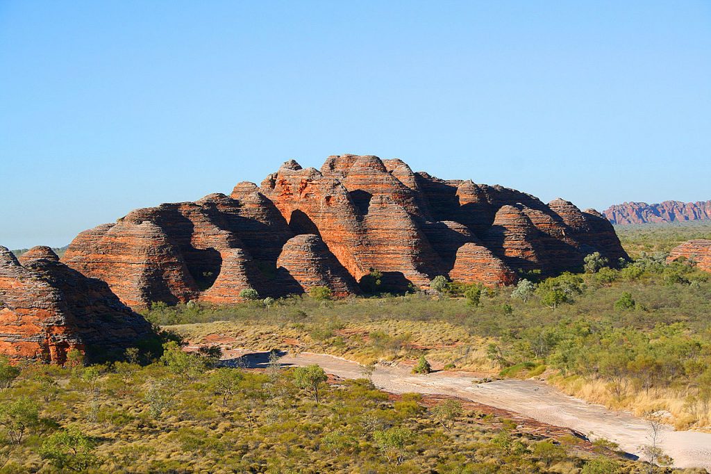
The geology of the Kimberley Range is diverse, featuring a variety of rock types that tell the story of its ancient past. The region is predominantly composed of sandstone, basalt, and granite. The sandstone formations, such as those found in the Bungle Bungles (Purnululu National Park), are particularly notable for their striking beehive-shaped domes. These sandstone structures were formed over millions of years through the deposition of sand, followed by compaction and cementation.
Basalt, a type of volcanic rock, is also prominent in the Kimberley. It formed from ancient lava flows that spread across the landscape, creating solidified layers of volcanic rock. Granite outcrops are found throughout the region, formed from slow-cooling magma beneath the Earth’s surface. These granite formations add to the geological complexity and visual diversity of the Kimberley Range.
Indigenous Populations
The Kimberley region has been inhabited by indigenous peoples for tens of thousands of years. The traditional custodians of the land include several Aboriginal groups, such as the Wunambal, Gaambera, Ngarinyin, and Bunuba peoples. These communities have a profound spiritual and cultural connection to the land, which is reflected in their stories, rituals, and art.
Indigenous Australians in the Kimberley have a deep understanding of the land and its resources, developed through generations of living in harmony with their environment. Their knowledge of local flora and fauna, as well as their land management practices, has been crucial for the survival and preservation of the region.
Historic Artwork
The Kimberley is home to some of the most significant and ancient rock art in the world. Indigenous rock art sites, such as those found in the Bradshaw (Gwion Gwion) and Wandjina styles, provide a perspective on the rich cultural heritage of the region’s Aboriginal peoples. These artworks, some of which are believed to be over 17,000 years old, depict ancestral beings, animals, and human figures, often in intricate and symbolic detail.
The Gwion Gwion art is characterized by elegant, elongated human figures adorned with ceremonial dress and accessories. The Wandjina art, on the other hand, features large, stylized human figures with distinctive halo-like headdresses and expressive faces. These artworks are not merely decorative; they hold profound spiritual significance and convey stories, laws, and traditions passed down through generations.
European Discovery and Mapping
European discovery and mapping of the Kimberley Range began in the early 19th century. The first recorded European to sight the region was William Dampier, an English explorer, who visited the northwestern coast of Australia in 1688 and again in 1699. However, comprehensive exploration and mapping did not occur until the late 19th century.
In 1879, Alexander Forrest, an Australian explorer, led an expedition through the Kimberley, documenting the landscape and its potential for settlement. His journey provided valuable insights into the region’s geography and resources. Subsequent expeditions by geologists and surveyors in the early 20th century further mapped the area, uncovering its rich mineral deposits and unique geological features.
Climate
The Kimberley region experiences a tropical monsoon climate, with distinct wet and dry seasons. The wet season, from November to April, brings heavy rainfall, thunderstorms, and occasional cyclones. This period is crucial for replenishing water sources and sustaining the region’s diverse ecosystems.
The dry season, from May to October, is marked by clear skies, warm temperatures, and low humidity. During this time, rivers run dry and water becomes scarce. The contrast between the wet and dry seasons creates a challenging environment for both wildlife and human inhabitants, who must adapt to the seasonal variations in water availability and temperature.
Flora and Fauna
The Kimberley region boasts an incredibly diverse range of flora and fauna, many of which are unique to the area. The varied habitats, from coastal mangroves and savannah woodlands to rocky escarpments and freshwater wetlands, support a wide array of plant and animal species.
**Flora**: The Kimberley’s plant life includes boab trees (Adansonia gregorii), which are iconic symbols of the region. These distinctive trees, with their bulbous trunks and sprawling branches, are well adapted to the arid environment. Other notable plant species include the Kimberley rose (Brachychiton viscidulus) and various species of spinifex grass.
**Fauna**: The Kimberley is home to an array of wildlife, including several species of mammals, reptiles, birds, and amphibians. Noteworthy mammals include the northern quoll, the short-eared rock-wallaby, and the golden-backed tree-rat. Reptiles such as the frill-necked lizard and the freshwater crocodile are also found in the region.
The birdlife in the Kimberley is diverse, with species such as the Gouldian finch, the red-winged parrot, and the wedge-tailed eagle commonly spotted. The region’s waterways and wetlands provide crucial habitats for various amphibians and aquatic species.
Threats and Preservation
Despite its remote location, the Kimberley Range faces several environmental threats that endanger its unique ecosystems and cultural heritage. Key threats include:
**Mining and Resource Extraction**: The Kimberley Range is rich in mineral resources, including diamonds, iron ore, and natural gas. While resource extraction contributes to the local and national economy, it poses significant risks to the environment. Mining operations have lead to habitat destruction, water pollution, and disruption of ecosystems.
**Climate Change**: Climate change poses a substantial threat to the Kimberley region. Rising temperatures, changing precipitation patterns, and more frequent extreme weather events can exacerbate existing environmental challenges. These changes can impact water availability, alter habitats, and increase the vulnerability of species to extinction.
**Invasive Species**: The introduction of invasive species, such as feral cats, cane toads, and weeds, has had detrimental effects on native flora and fauna. Invasive species can outcompete, prey upon, or otherwise disrupt local ecosystems, leading to declines in native species populations.
**Tourism and Human Activity**: While tourism brings economic benefits and increased awareness of the Kimberley’s natural beauty, it also increases pressures on the environment. Increased human activity can lead to habitat degradation, pollution, and disturbance of wildlife. Responsible tourism practices and sustainable management are essential to mitigate these impacts.
Preservation Efforts
Efforts to preserve the Kimberley region involve a combination of government initiatives, indigenous-led conservation programs, and community involvement. Key preservation strategies include:
**Protected Areas**: Establishing protected areas, such as national parks and nature reserves, is crucial for safeguarding the Kimberley’s unique ecosystems. Purnululu National Park, known for the Bungle Bungles, and the Prince Regent National Park are examples of areas designated for conservation.
**Indigenous Land Management**: Indigenous communities play a vital role in preserving the Kimberley through traditional land management practices. Indigenous ranger programs, such as the Kimberley Land Council’s ranger program, support Aboriginal custodians in managing and protecting their ancestral lands. These programs combine traditional knowledge with modern conservation techniques to address environmental challenges.
**Sustainable Tourism**: Promoting sustainable tourism practices helps balance the benefits of tourism with the need to protect the environment. Eco-friendly tourism initiatives, such as guided tours that follow strict environmental guidelines and the use of low-impact infrastructure, can minimize the negative impacts of tourism. Educating visitors about the region’s ecological and cultural significance fosters a sense of responsibility and encourages respectful behavior.
Final Thoughts
The Kimberley Range in Australia is a region of extraordinary geological, ecological, and cultural significance. Its ancient landscapes, diverse flora and fauna, and rich indigenous heritage make it a unique and valuable part of the world. However, the Kimberley faces numerous threats that require concerted efforts for preservation.
By understanding the history, geology, and biodiversity of the Kimberley, we can appreciate its importance and the need to protect it for future generations. Through a combination of protected areas, indigenous land management, research, community engagement, policy enforcement, and sustainable tourism, it is possible to safeguard this remarkable region.
Preserving the Kimberley is not only about protecting the environment but also about honoring the cultural heritage and traditional knowledge of its indigenous peoples. Their deep connection to the land provides invaluable insights into sustainable living and conservation. By working together, we can ensure that the Kimberley remains a vibrant and thriving ecosystem, a testament to the natural and cultural richness of Australia.