World

The Kimberley Range

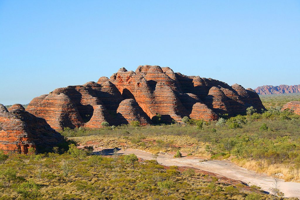
The Kimberley Range, or the Kimberleys, in Australia is one of the most remote and geologically interesting regions in the world. In this article we take a deep dive into the region, covering its formation, size, topography, rock types, discovery and mapping, indigenous populations, historic artwork, climate, flora and fauna, as well as the threats it faces and efforts for its preservation. Where and When? The first thing to note about the Kimberley range is just how remote it is. It is found on the very north west tip of the Australian continent. It is part of the state of Western Australia, which at 2,527,013 square kilometers would just edge out Algeria to be the world’s 10th largest country were it to secede from the rest of Australia and go it alone. This vast region contains a population of just 2.8 million people, which would put it at 136 on a list of the most populous countries. For context, Algeria, its nearest neighbour in land area is itself a relatively sparsely populated country, and has a population of 46 million people. The capital of our imaginary new nation of western Australia would be Perth, a city located 1,670 km to the south, containing 2.3 million people of that total. This leaves just half a million people spread throughout the remaining 2.5m kilometers squared. In short, the Kimberleys are remote.  The Kimberley Range is also an ancient landscape. It was formed as part of the Kimberley Craton, which began forming 2.5 billion years ago. Today’s surface is likely to have solidified during the Proterozoic Eon, around 1.8 billion years ago. The range was primarily shaped by volcanic activity, tectonic movements, and erosion processes. Since the surface layer solidified,  Layers of volcanic rock and sediment have further shaped the landscape. Whilst the region is not directly on a tectonic plate boundary, the Eurasion plate and the Indo-Australian plate run along the southern edge of the lesser Sunda Islands just across the Timor sea. Topology The Kimberley region covers a vast area of about 423,000 square kilometers (163,000 square miles), just a little smaller than the country of Iraq. This makes  it one of Australia’s largest wilderness areas. The age of the surface rocks and the relative lack of tectonic activity in the area has allowed time to weather and round the higher peaks of the area, giving the Kimberleys a more gentle and rolling landscape. The highest peaks in the Kimberleys all sit in the Wunaamin Miliwundi Range in the south of the Kimberleys. Mount Broome, which stands at 946 meters (3,104 feet) above sea level, is the region’s highest peak.  Rock Types The geology of the Kimberley Range is diverse, featuring a variety of rock types that tell the story of its ancient past. The region is predominantly composed of sandstone, basalt, and granite. The sandstone formations, such as those found in the Bungle Bungles (Purnululu National Park), are particularly notable for their striking beehive-shaped domes. These sandstone structures were formed over millions of years through the deposition of sand, followed by compaction and cementation. Basalt, a type of volcanic rock, is also prominent in the Kimberley. It formed from ancient lava flows that spread across the landscape, creating solidified layers of volcanic rock. Granite outcrops are found throughout the region, formed from slow-cooling magma beneath the Earth’s surface. These granite formations add to the geological complexity and visual diversity of the Kimberley Range. Indigenous Populations The Kimberley region has been inhabited by indigenous peoples for tens of thousands of years. The traditional custodians of the land include several Aboriginal groups, such as the Wunambal, Gaambera, Ngarinyin, and Bunuba peoples. These communities have a profound spiritual and cultural connection to the land, which is reflected in their stories, rituals, and art. Indigenous Australians in the Kimberley have a deep understanding of the land and its resources, developed through generations of living in harmony with their environment. Their knowledge of local flora and fauna, as well as their land management practices, has been crucial for the survival and preservation of the region. Historic Artwork The Kimberley is home to some of the most significant and ancient rock art in the world. Indigenous rock art sites, such as those found in the Bradshaw (Gwion Gwion) and Wandjina styles, provide a perspective on the rich cultural heritage of the region’s Aboriginal peoples. These artworks, some of which are believed to be over 17,000 years old, depict ancestral beings, animals, and human figures, often in intricate and symbolic detail. The Gwion Gwion art is characterized by elegant, elongated human figures adorned with ceremonial dress and accessories. The Wandjina art, on the other hand, features large, stylized human figures with distinctive halo-like headdresses and expressive faces. These artworks are not merely decorative; they hold profound spiritual significance and convey stories, laws, and traditions passed down through generations. European Discovery and Mapping European discovery and mapping of the Kimberley Range began in the early 19th century. The first recorded European to sight the region was William Dampier, an English explorer, who visited the northwestern coast of Australia in 1688 and again in 1699. However, comprehensive exploration and mapping did not occur until the late 19th century. In 1879, Alexander Forrest, an Australian explorer, led an expedition through the Kimberley, documenting the landscape and its potential for settlement. His journey provided valuable insights into the region’s geography and resources. Subsequent expeditions by geologists and surveyors in the early 20th century further mapped the area, uncovering its rich mineral deposits and unique geological features. Climate The Kimberley region experiences a tropical monsoon climate, with distinct wet and dry seasons. The wet season, from November to April, brings heavy rainfall, thunderstorms, and occasional cyclones. This period is crucial for replenishing water sources and sustaining the region’s diverse ecosystems. The dry season, from May to October, is marked by clear skies, warm temperatures, and low humidity. During this time, rivers run dry and water becomes scarce. The contrast between the

The Kimberley Range Read More »

South Georgia and the Sandwich Islands

South Georgia and the South Sandwich Islands are a remote and rugged British Overseas Territory located in the southern Atlantic Ocean. This territory, known for its dramatic landscapes and rich biodiversity, consists of the main island of South Georgia and the smaller South Sandwich Islands. These islands have a fascinating geological history, a unique ecosystem, and a complex human history that has shaped their current status. Location and Formation South Georgia is situated about 1,300 kilometers southeast of the Falkland Islands and approximately 2,000 kilometers east of South America’s southern tip. The South Sandwich Islands lie further southeast of South Georgia, forming a volcanic island arc. The islands are positioned along the Scotia Arc, a geological formation that links the Andes in South America to the Antarctic Peninsula.  The formation of South Georgia and the South Sandwich Islands can be traced back to tectonic activity associated with the South American Plate and the Antarctic Plate. South Georgia is primarily composed of sedimentary rocks formed during the Jurassic period, around 150 million years ago. These rocks were later uplifted due to tectonic forces. The South Sandwich Islands are much younger, with ongoing volcanic activity that continues to shape their landscape. The islands themselves are volcanic in origin, with Mount Belinda on Montagu Island being an active volcano. Historic exploitation The first recorded sighting of South Georgia was by the English merchant Anthony de la Roché in 1675. However, it was not until 1775 that Captain James Cook made the first documented landing on the island during his second voyage. Cook claimed the island for Britain and named it “Isle of Georgia” in honor of King George III. The South Sandwich Islands were later discovered by Captain James Cook in 1775, during the same voyage. South Georgia has a significant history of human exploitation, particularly during the 19th and early 20th centuries when it was a hub for the whaling industry. Whaling stations were established on the island, and for several decades, South Georgia was the center of the southern hemisphere’s whaling operations. At its peak, the islands were home to around 2,000 people. Most were transient sailors, but others were near permanent residents on the island, all of the population was associated with the whaling industry in one capacity or another.   The remnants of the whaling era are still visible today, with rusting equipment and abandoned buildings serving as reminders of this period. The whaling industry had a profound impact on the local ecosystem, with many whale species becoming endangered due to over-exploitation. Whalers targeted species like the blue whale, fin whale, and humpback whale, leading to a drastic decline in whale populations. This is particularly problematic due to the long breeding cycles of many of the species targeted making replenishment difficult. By the mid-20th century, the whaling industry had collapsed, and the whaling stations were abandoned. A Remarkable Rescue The island is closely associated with the famous Antarctic explorer Sir Ernest Shackleton. Shackleton’s ill-fated Endurance expedition in 1914-1917 is one of the most remarkable stories of survival in polar exploration history. After their ship was trapped and crushed by pack ice, the entire crew were forced to abandon ship onto the pack ice and make their way to the nearest land with whatever they could carry. Upon reaching land, a plan was devised to reach safety.  So it was that Shackleton and 5 of his crew made an arduous journey rowing from Elephant island on the very tip of the Antarctic peninsula to South Georgia. A journey of some 1,300 kilometers across the treacherous Southern Ocean. They later mounted a successful rescue mission for the remaining crew still stranded on Elephant island. Despite losing their ship to the Antarctic winter ice and being stranded on the inhospitable and barron Elephant Island, not a single member of the crew was lost. It was a remarkable result at a time where loss of entire ships with all hands was a routine occupational hazard. Shackleton’s epic voyage and subsequent rescue mission are commemorated on the island. Visitors can visit Grytviken, the site of the former whaling station, where Shackleton’s grave and a small museum dedicated to his exploits are located. Grytviken serves as a poignant reminder of the island’s role in the history of polar exploration and the enduring human spirit. Shackleton and cres launching the James Caird from Elephant Island Probably Frank Hurley, the expedition’s photographer, Public domain, via Wikimedia Commons Flora and Forna The harsh climatic conditions and rugged terrain of South Georgia and the South Sandwich Islands limit the types of vegetation that can survive there. The flora primarily consists of hardy mosses, lichens, and tussock grasses that have adapted to the cold and windy environment. These plants play a crucial role in stabilizing the soil and providing habitat for various animal species. There are no trees or bushes higher than a few centimeters tall. Despite the limited plant life, the islands are renowned for their rich and diverse fauna. South Georgia, in particular, is a haven for wildlife, hosting large populations of seals, penguins, and seabirds. The island is home to several species of seals, including the Antarctic fur seal and the southern elephant seal. The populations are all supported almost exclusively on the rich abundance of sealife surrounding the islands.  The birdlife on South Georgia is equally impressive. Albatrosses, petrels, and skuas are among the many seabird species that nest on the island. The South Georgia pipit, the world’s southernmost songbird, is endemic to the island. South Georgia is also one of the world’s most important breeding grounds for king penguins, with colonies numbering in the hundreds of thousands Current uses Today, there is no permanent population on the island, although the British Antarctic Survey and other research groups have bases with rotating personnel completing scientific research. The economy of South Georgia and the South Sandwich Islands is primarily based on fisheries and tourism, but with no permanent population, and no real need for the normal societal

South Georgia and the Sandwich Islands Read More »

Washington D.C.

There’s something undemocratic at the heart of US democracy. The very ground that the US Capitol building, the Whitehouse, the US Supreme court, the Lincoln and Washington monuments, and all the famous buildings synonymous with US democracy all sit in a city without a voice. The people of Washington DC may be surrounded by the infrastructure of US democracy, but the very proximity to political power means the residents of D.C do not enjoy the same representation as every other American citizen.  In order to make sense of this, we need to head all the way back to the founding of the US itself. In this article we will look at the foundation of this great city, the strategic reasons for its location, its intricate relationship with politics and more specifically, the reasons behind the lack of representation in the US congress.  The Birth of a National Capital Washington DC is not an old city, even by American standards. Many of the cities that we know and love were founded and thriving long before the establishment of Washington DC. Cities such as Albany and Jersey City had been settled for well over 100 years by the time they broke ground in Washington DC. Philadelphia, which served as the fledgling nation’s capital city on and off throughout the latter part of the 1700s, was the largest city of the 13 colonies with close to 40,000 people. Philadelphia, along with other cities such as Boston and New Amsterdam (soon to be renamed to its more familiar New York) were instrumental in the formation of the US constitution and the first continental congresses in a way that Washington DC simply wasn’t.  With all these thriving metropolises, why bother with a new capital at all? And when exactly did the city come into existence if so much of early American history had already taken place elsewhere? It’s fair to say that this period was rather a busy one in the history of the USA. The 13 colonies had just fought, and won, a bruising and bloody revolutionary war against the British and were in full swing with the crafting of the US constitution. At that time, the 13 colonies thought of themselves almost as independent nations with a shared goal of ridding themselves of the British almost as much as they thought of themselves as a single nation. With this delicate balance in mind, the Founding Fathers sought a neutral location that would not favor any particular state, thereby avoiding regional biases. The location for the capital was selected by three of the big hitters of US history.  President Washington himself, in collaboration with Secretary of State Thomas Jefferson and Treasury Secretary Alexander Hamilton. The Residence Act of 1790, signed by President George Washington, authorized the creation of a new capital along the Potomac River. The city was named in honor of George Washington, and “District of Columbia” was chosen to reflect Christopher Columbus. Pierre Charles L’Enfant, a French engineer and architect, was commissioned to design the city, envisioning grand avenues and significant public spaces that would embody the young nation’s aspirations. Where to put a national capital The Whitehouse The placement of Washington, D.C., along the Potomac River was a strategic decision influenced by several factors. As a matter of principle, the founders believed that the capital should be a federal city, and not beholden to any one state. For this reason, in the very first article of the constitution, the matter of the capital was explicitly settled with section 8 stating that congress shall have the power “to exercise exclusive legislation in all cases whatsoever, over such district (not exceeding ten miles square) as may …..” The clause goes on to talk about cession and other technical matters, suffice to say, the framers of the constitution thought that the independence from local politics of a new capital was very important.  Next up was a point of perception. Alexander Hamilton believed that the US government should be seen in good standing among other nations. The fledgling nation should therefore pay its debts, and by extension, the debts of the 13 founding colonies. This was an issue for the southern states that had paid off their debts and did not want to see the northern states benefit from debt relief. The compromise was for northern states to forego their claim that the capital should continue to be Philadelphia or New York, and the southern states would agree to the federalisation of all debts into the new government. The capital would then be sited in a central location. The final reason is purely practical, the Potomac River provided a navigable waterway that facilitated trade and transportation. The colonies stretched some 2,100km from Georgia in the south, up the eastern seaboard, to Maine (then a province of Massachusetts) in the north. This at a time when overland travel was in horse drawn carriages. In short, it needed to be central.  The proximity to important cities like Baltimore and Philadelphia also made it a convenient choice. Additionally, the land for the new capital was donated by the states of Maryland and Virginia. The new country finally had a political heart!  Planning and construction began almost immediately. The announcement of the site was made by President Washington on January 24th 1791 and the cornerstone of the Whitehouse was laid on October 13th 1792. Just 9 years after the initial building works, the 1800 census showed a population of 8,144. It was a staggeringly successful opening decade. But, I hear you say….what on earth does any of this have to do with a deficit in democracy for the people of Washington DC? Population explosion Arial view of Washington D.C. Roll forwards a few hundred years and Washington, D.C. is a melting pot of cultures and ethnicities, reflecting the broader diversity of the United States. The demographic composition includes a significant African American community, making up about 45% of the population. This is followed by White (36%), Hispanic or

Washington D.C. Read More »

Uluru

Uluru, (we will not be using the term ‘Ayers Rock’) is a sandstone monolith in the Northern Territory in Australia. It’s a geological wonder in its own right, but it’s also a cultural and spiritual icon for the indigenous Anangu people. This article explores the formation and geological characteristics of Uluru, its cultural importance, its troubled history with non-indigenous people, and the journey towards its return to indigenous ownership. How a monolith forms Uluru’s formation dates back 550 million years. During the late Neoproterozoic and early Cambrian periods, at this time life was just getting started with the world famous Cambrian explosion. The region was part of an inland sea. Over time, sediments were washed from land, through river systems, and found their way to this sea. Through the eons the relentless depositing of minute amounts of sand and gravel compressed into sandstone and conglomerate rock formations.  Around 400 million years ago, just as the first insects began to appear in the fossil record, tectonic activity began to shift these rock layers. The crust buckled and folded as two converging plates pushed relentlessly together, creating large folds and faults known as an inselberg or “island mountain.” Eventually, one of these inselbergs broke the surface and was exposed to the elements. This is how the great monolith came into being. If you look closely, you can still sort of make out the rock strata running diagonally down the face of Uluru as erosion has continued to weather away the softer rock Size and Shape Uluru is the second largest monolith in the world, behind Mount Augustus, also in Australia. It stands 348 meters (1,142 feet) high. Much like an iceberg, most of its bulk lies underground. It has a circumference of about 9.4 kilometers (5.8 miles). The rock is 2.2 kilometers (1.4 miles) long and 1.6 kilometers (1 mile) wide. Its surface is characterized by its deep grooves, ridges, and caves formed by erosion. The rock’s striking red color comes from its iron oxide coating, which contrasts with the non-weathered grey rock beneath. The colors of Uluru change dramatically at different times of the day and year, ranging from deep reds and purples at sunrise and sunset to softer ochres and browns during the day. Similar Formations Around the World While Uluru is unique in many ways, there are similar formations around the world that share certain geological characteristics: Kata Tjuta (The Olgas):  Located about 25 kilometers (16 miles) west of Uluru, Kata Tjuta is a group of large, domed rock formations. Like Uluru, they are composed of conglomerate rock and hold significant cultural importance for the Anangu people. Devils Tower (Wyoming, USA):  This monolithic igneous formation rises 386 meters (1,267 feet) above the surrounding terrain. It is composed of phonolite porphyry and has significant cultural importance for several Native American tribes. Sigiriya (Sri Lanka):  Also known as Lion Rock, Sigiriya is an ancient rock fortress. Rising 200 meters (660 feet) above the jungle, it is composed of hardened magma from an extinct volcano and is surrounded by the remnants of gardens and palaces. El Capitan (California, USA):  Perhaps one of the few monoliths that rival Uluru in recognizability. This vertical rock formation in Yosemite National Park is made of granite and rises about 900 meters (3,000 feet) from the valley floor. It is a popular destination for rock climbers. Cultural importance to the Anangu people For the Anangu, the traditional owners of Uluru, the rock is a sacred site. It is intertwined with Tjukurpa, often translated as “Dreamtime” or “the Dreaming,” which encompasses the spiritual beliefs, law, and history of the Anangu people. Uluru is considered a living cultural landscape, and its features are linked to ancestral beings who traveled across the land, creating the world and laying down laws and customs. The Anangu have a deep spiritual connection to Uluru, and it features prominently in their creation stories and rituals. The rock’s various caves, waterholes, and rock formations are considered sacred sites are associated with different ancestral beings, rituals, ceremonies and stories Cultural Practices and Knowledge The Anangu people have traditionally used the land around Uluru for hunting, gathering, and ceremonies. Their knowledge of the local flora and fauna, weather patterns, and land management practices has been passed down through generations. This traditional ecological knowledge is essential for maintaining the health of the landscape and preserving biodiversity. There are several sites within and around Uluru that have gender specific roles in Anangu culture. There are strict protocols within the culture that the Anangu men and women do not interfere with each other’s sacred sites and cultural practices. The sites are not widely known and the exact location of virtually all of the sites are known only to the Anangu people.  The Anangu people have a rich oral history with stories of their ancestors, their travels and of the history of the land. Much of the history of the Anangu people can also be found in cave art found throughout Uluru. The Anangu people have a distinctive dot-painting style. This tradition continues to this day, with Anangu artists continuing to create artworks depicting Tjukurpa stories.  Initial European Discovery and Naming Sir Henry Ayers Photographer: J. Hubert Newman., Public domain, via Wikimedia Commons After many thousands of years of aboriginal stewardship of Uluru the South Australian government was on the hunt for new lands to colonise. In 1873, the South Australian government was looking for new pasture land, or areas for future development. They engaged William Gosse, the British born explorer, to map a large region of Australia to the south of Alice springs. He departed Alice springs on 21st of April 1873 with a crewe of 7 people – including 3 Afghans and an aboriginal boy named Moses. On 19th June of that year, Uluru was first sighted by Europeans. Gosse named it Ayers Rock in honor of Sir Henry Ayers, the Chief Secretary of South Australia. This name became the commonly used term for Uluru in Western contexts,

Uluru Read More »

The Jurassic Coast

Imagine yourself strolling along the beaches of Lyme Regis in 1824. Beside you strolled a woman by the name of Mary Anning. The stroll has all the hallmarks of an uneventfully pleasant morning walk, but Anning spots something protruding from the soft mudstone cliffs. It appears to be nothing more than a piece of rock but to her well trained eyes, it represented the find of a lifetime. It would come to define the beach, and the region for centuries to come. Anning had discovered the fossilized remains of a large, carnivorous dinosaur now known as the Scelidosaurus. Let’s explore the Jurassic coast! The Jurassic Coast of England is usually considered to start at Orcombe point in the west, stretch for 95 miles along the beautiful coastlines of Devon and Dorset before terminating at Old Harry Rocks in the far east. In 2001 it was recognised as a UNESCO World Heritage site renowned for its exceptional examples of geological formations. Geology through time Despite being called the Jurassic coast, its rock formations span the Triassic, Jurassic, and Cretaceous periods. These rock layers provide an almost continuous record of the Mesozoic Era, spanning approximately 185 million years of geological time. The geology of the coast is complex and varied, featuring a range of rock types and formations that have been shaped by millions of years of natural processes. The Triassic period, which dates from 252 to 201 million years ago, is represented by the red sandstones and mudstones found around the East Devon coast. These rocks formed in arid desert conditions and are often rich in fossilized remains of early reptiles and amphibians. During this time, the globe would look very different to today. The supercontinent of Pangea was still a single land mass. During the Jurassic period, this small corner of Devon was on the edge of a small inland sea. The climate at the time was much hotter and drier than the present. The single solitary landmass did, however, give rise to far greater seasonal variations in temperature and weather than the present day.  As you move east along the coast, you progress into the Jurassic period, from which the region gets its name. These rocks date from about 201 to 145 million years ago. By the Jurassic, the supercontinent of Pangea had broken up into several smaller, but still super, continents. This area was on a continent called Gondwana. The area was now entirely submerged in shallow sea and as a result there is an abundance of marine fossils, including ammonites, belemnites, and marine reptiles such as ichthyosaurs and plesiosaurs. This period is best represented by the limestone and shale cliffs of Dorset.  Artists impression of an Ichthyosaurs The Cretaceous period, dating from about 145 to 66 million years ago, is represented by the chalk cliffs found around the Isle of Purbeck and parts of East Devon. These rocks were also formed in warm, shallow seas so show the same abundance of fossilized sealife. This area also shows the beginnings in the fossil records of early birds and small mammals. Key sites to the Jurassic Coast The Jurassic Coast is dotted with numerous geological landmarks, each offering unique insights into Earth’s history. Lyme Regis Known as the “Pearl of Dorset,” the seaside town of Lyme Regis is famous for its fossil-rich beaches and cliffs. Lyme Regis has been a significant port and fishing village since medieval times. The town’s history is intertwined with maritime activities, and it has a charming mix of historic buildings and narrow streets. The Lyme Regis Museum offers insights into the town’s geological and cultural history, with exhibits on Mary Anning and her fossil discoveries. The town has a long history of fossil hunting, with notable figures like our very own Mary Anning having made significant discoveries here. The cliffs around Lyme Regis are part of the Blue Lias formation, which is characterised by interspersed layers of shale and clay. The formation covers a wide area of southern and central England, stretching as far north as Warwickshire. The richness of the finds in Lyme Regis as compared to elsewhere in the formation is thanks in no small part to the relentless wearing of the cliffs by the sea, exposing fresh shale on a regular basis. The formation dates back to the early Jurassic period and is rich in ammonites and marine reptile fossils. Fossils such as Ichthyosaurs and Plesiosaurs have been found along with an abundance of amonites and Belemnites in the cliffs of Lyme Regis Mary Anning in Lyme Regis By Eddusgl – Own work, CC BY-SA 4.0, https://commons.wikimedia.org/w/index.php?curid=146386244 Chesil Beach No tour of the Jurassic coast would be complete without a stop at Chesil Beach. It is a remarkable 18-mile-long shingle spit that stretches from West Bay to the Isle of Portland. This natural feature is an excellent example of the process of longshore drift, where sediments are transported along the coast by wave action. The beach is also a natural barrier, creating the Fleet Lagoon to its inland side, a unique habitat for wildlife.  At the far end of the beach lies the Isle of Portland. Known for its high-quality, bright white limestone, which has been quarried for centuries and used in notable buildings such as St. Paul’s Cathedral in London. The island’s history is rich with tales of shipwrecks, smugglers, and military fortifications, including the remains of Portland Castle, built by Henry VIII. Portland was the site of beautifully preserved specimens of Dapedium, a large fish with an armoured body. Durdle Door One of the most iconic landmarks on the Jurassic Coast, Durdle Door is a natural limestone arch near Lulworth in Dorset. The arch was formed by the erosive power of the sea, which has gradually worn away the softer rock around the harder limestone, creating this stunning feature. The formation is ripe with local folklaw from the legend of the sea serpent, the story of the star crossed lovers, the fisherman and the mermaid or the giants

The Jurassic Coast Read More »

The Congo River

The Congo River! Second longest river in the world to the Nile, Second largest river by discharge to the Amazon, Second largest river drainage basin area to the Amazon. Second largest rainforest to…the Amazon. You might think that the Congo river is the perennial silver medalist. You might think that there are more interesting rivers around the world, but don’t pity this mighty river. It’s a fascinating body of water full of stories and meaning. It plays a crucial part in the economies and cultures of the regions it runs through, it’s a vital part of the natural world of a great swathe of the African continent. If you’re looking for a record that sets the Congo River apart, then look down. The Congo River is staggeringly deep, it’s by far the deepest river in the world with some very specific geological factors that force the river deep into the earth. Let’s explore! Formation and History The Congo River’s formation is a result of tectonic activities causing the uplift of the East African Rift. Here, the African plate has spent the last 25 million years slowly tearing itself in two, the newly formed Nubian plate and Somali plate are sliding apart at around 6-7mm per year. The area is littered with other features of this tectonic activity such as Lake Tanganyika, mount Kilimanjaro, and the Danakil Depression, each of which are fascinating in their own right. The Congo River basin is estimated to have formed over 1.5 million years ago during the Pleistocene epoch when tectonic activity caused the landscape to shift and create the vast drainage basin we see today. Source and Mouth The most upstream source of the Congo river is the Chambeshi river. It begins its journey to the Atlantic ocean high up on the Zambian Plateau at an elevation of 1,760m (5,774 feet) above sea level and just 430 miles from the Indian Ocean. The Chambeshi flows through the Bangweulu swamps where it merges with the Luapula River. The Luapula River flows in a northeastern direction before joining the Lualaba, which is sometimes considered the main upper course of the Congo as it contributes by far the greatest share of water by volume at this point of the river’s journey.  By Kmusser – Own work, Elevation data from SRTM, drainage basin from GTOPO, all other features from Natural Earth, CC BY-SA 4.0, https://commons.wikimedia.org/w/index.php?curid=75858826 The river charts a course due north for the next 1,600km (1,000 miles) through the heart of the Democratic Republic of Congo. In this section of the river, you may think that it will simply run its course all the way to the ocean in a more or less straight line, much like the Nile. However, at the town of Kisangani, almost exactly on the equator, it turns eastward and finally changes its name to The Congo River. From here it takes a giant southwestbound arc across the north of the Democratic Republic of Congo. For roughly 1,000km of this journey the river forms the (somewhat disputed) border between the Democratic Republic of Congo and the Republic of Congo, eventually bisecting the two capitals of Brasserville and Kinshasa. These two cities, formerly the capital cities of the states of French and Belgian Congo, hold the record for the closest capital cities at just one mile apart (we’re not counting Rome and the Vatican!). The river eventually empties into the Atlantic Ocean at the delightfully named Port of Banana on the border of the Democratic Republic of Congo and Angola. Unlike many other rivers of comparable scale, the Congo River doesnt really have much of a mouth to speak of. Look at the Amazon, Mississippi or Nile and you will notice that their mouths spread into broad outflows often hundreds of kilometers across and filled with multiple streams. The Congo River, on the other hand, is a little over 5 kilometers at the point it discharges into the ocean. Drainage Basin The drainage basin of the Congo River is penned in by various geographical features. To the north is the Central African Republic, where the watershed takes rivers north and east into the gulf of Guinea or the endorheic basin of Lake Chad. To the northeast, rivers flow mostly into the Nile. To the east, the great Rift Valley forms an impenetrable obstacle, all rivers east of the great rift, such as the Tana in Kenya, the Pagnani in Tanzania eventually find their way into the Indian ocean. To the south a series of mountain ranges, plateaus and highlands in Zambia and Angola force the Congo River northbound. To the northeast, the rivers of Gabon and Cameroon flow directly into the Atlantic Ocean, Gulf of Guinea, or form tributaries of the Niger river.  All in all, this gives the Congo drains an impressive 3,730,881 square kilometers of area in the center of Africa. This is the second largest drainage basin of any river in the world.. At Kinshasa and Brazerville, the flow rate ranges from a high of 65,000 to a low of 21,000 cubic meters. It is estimated (but not confirmed) that a series of floods in 1962 caused flow rates in excess of 73,000 cubic meters which is thought to be the highest flow rate ever down the river. Widest and Deepest Points The Congo River is unusual in many ways. It is broadly split into three sections, the upper, mid and lower Congo. The upper Congo consists of all tributaries upstream of the town of Kisangani. As with many river systems, the upper Congo River is interrupted at regular intervals with waterfalls and rapids, including the Boyoma falls at Kisangani. These waterfalls contribute to generally challenging navigability and make the upper Congo unusable for all other than local traffic.  From Kisangani to the Malebo pool is considered the middle Congo.  As it meanders down through the Central African republic, it splits and reforms in channels, side channels and branches, sometimes forming islands many miles across. Many of these islands have

The Congo River Read More »

The Imago Mundi

The Babylonian World Map, also known as the Imago Mundi, is one of the oldest known representations of our world. This ancient map offers a fascinating glimpse into the geographical knowledge and worldview of the Babylonians over two and a half millennia ago as well as their expertise as craftsmen. In this article, we will look at the discovery of the map, its creation, materials, authorship, similar maps, what it depicts, its accuracies and inaccuracies, its impact and legacy, and its current location. Discovery and Background The Map was discovered during archaeological excavations in the ruins of the city of Sippar in the late 19th century. Sippar was one of the oldest cities in Mesopotamia with origins dating back as far as 2900 BC. It was found on the eastern banks of the Euphrates close to Baghdad in modern day Iraq. Sippar was a significant urban center with a population of up to 40,000 inhabitants, comparable in size with other cities such as Ur and Uruk. It was known for its temple dedicated to the sun god Shamash. Given its location on the Euphrates, it was also an important trading outpost.  By MapMaster – Own work, CC BY-SA 4.0, https://commons.wikimedia.org/w/index.php?curid=3578442 Creation and Materials The exact date of the map’s creation is not well-documented, but it has been estimated at no earlier than the 9th century BC. It was part of a series of finds that provided substantial insights into ancient Mesopotamian civilization. The map was created during the Neo-Babylonian period. It is inscribed on a clay tablet using the now extinct Cuneiform Akkadian language, a writing system developed in the city of Akkad, and used across Mesopotamian. The tablet measures approximately 12.2 cm by 8.2 cm, with a generally better preserved upper half, the lower extremities having been lost.  The clay tablet was likely produced by a Babylonian scribe. Although the identity of the scribe remains unknown, there are some clues in the text contained on the front of the tablet. This map is part of a larger tradition of Mesopotamian cartography and geographical texts, reflecting the intellectual and scholarly pursuits of the time. The use of clay tablets was common in Mesopotamia due to the abundance of clay in the region and the durability of baked tablets. What does the map actually depict? By Osama Shukir Muhammed Amin FRCP(Glasg) – Own work, CC BY-SA 4.0, https://commons.wikimedia.org/w/index.php?curid=42131230 The map is divided into three sections. On the front, the pictorial representation, the map itself, is found on the lower two thirds of the front of the tablet. The upper third is text. On the rear of the tablet is also text. The structure and information of each section differs greatly, implying that the three sections may have been compiled from three different and possibly unrelated original sources. The first thing to notice of the map section are the two circles that cover more than half of the map portion. They are labeled ‘Maratum’ which literally translates as ‘Bitter River’. It is thought that this represents the Persian Gulf. The label refers to the salt sea. The Persian gulf was over 500km from Sippar.  Inside the circles, there are 7 additional smaller circles, which are thought to represent 7 cities, with Babylon being represented in the center at the top. The parallel lines at the bottom of the map represent marshland, which could be the current day Iraq Central marshes, Hammar marshes or Hawizeh marshes. A line in the north east corner of the map appears to be the modern day Zargos Mountain range, which runs from south east Turkey, down the eastern border of Iraq and onwards into western Iran as far south as the strait of Hormuz. All of the labeling and annotation on the inside of the circles is in Cuneiform. Seven or eight triangular sections outside the water circle represent named “regions” (nagu). The descriptions for five of them have survived. The map indicates features spread across much of eastern Iraq, an area of many hundreds of thousands of square kilometers.  The text above the map describes the creation of the land and sea by Marduk, the patron saint of Babylon. It is written that he parted the primeval ocean, called Tiamat, thus raising dry land.  The next few lines refer to at least 15 animals, the Mountain Goat, Gazelle, Lion, Wolf, Monkey (and female Monkey), Ostrich, Cat and Chameleon. Other than the Cat, none of the animals listed were to be found in ancient mesopotamia. The last two lines of the text refer to three legendary heroes: Utnapištim (the hero of the Flood), Sargon (ruler of Akkad), and Nur-Dagan the King of Buršaḫanda (opponent of Sargon). The back side contains at least 29 lines of text and seems to be a description of the nagu, or regions of ancient Mesopotamia. It is assumed that the nagu listed on the rear are the same nagu as depicted on the front. After an introduction, possibly explaining how to identify the first nagu, the pattern for the remaining descriptions is to list the nagu by number, and state the distance in leagues that one must travel to get there from the previous nagu. The distances listed on the rear do not seem to correspond to any scale depicted on the front. This could be because such scale drawings were not helpful when journeys were measured in days or weeks. It could more simply be that the rear of the tablet is referring to a different set of nagu than those represented on the front of the map.  A short description is given for each of the eight nagu, but those of the first, second, and sixth are too damaged to read. The fifth nagu has the longest description, but this too is damaged and partially unreadable.  There are some rather strange pieces of information that the author though to include, such as: ‘The third nagu may be a barren desert, impassable even for birds: A winged bird cannot safely

The Imago Mundi Read More »

The Great Migration

Imagine a Europe that was centrally controlled. Politicians operated in a single party and controlled the economy, infrastructure, culture and lifestyles of its citizens. One year, they decide that every man, woman and child in western Europe should migrate to a different country. Every person in Germany, the UK, France, Italy, Spain, Poland, Romania, the Netherlands, Belgium, Sweden, Czech Republic, Greece, Portugal, Hungary, Austria, Switzerland, Bulgaria, Denmark, Slovakia, Ireland and Croatia is encouraged to move to a new country, say Latvia. On top of this, the infrastructure in Latvia is non-existent, mega-cities will need to be built from scratch, entire societies will need to be brought into existence, and those new societies will eradicate the rural lifestyle that existed previously. What’s more, we have just 40 years to complete this mammoth task. Imagine the utter chaos that this would cause. Imagine the social strife, the loss of community and traditions, the re-ordering of an entire society from sleepy rural to high tech urban. This very change has occurred in living memory. Of all the population movements in world history, none can match the scale of rural to urban migration in China. It is the single most massive demographic shift in all of human history. This mass movement of people from the countryside to cities has profoundly reshaped China’s social, economic, and political landscapes, affecting everything from labor markets to environmental sustainability. It has seen the growth of urban centers of global size virtually unheard of outside of China. Firing the starting gun The large-scale migration from rural to urban areas in China began in the late 1970s, coinciding with the economic reforms initiated by Deng Xiaoping. These reforms, collectively known as the “Open Door Policy,” aimed to modernize China’s economy by introducing market-oriented principles and welcoming foreign investment. The result was an economic boom that created the marvel that is modern day Chinese manufacturing. The rate of migration has been staggering. Between 1979 and 2018, more than 500 million people moved from rural areas to cities, the majority of this migration has been from the rural north and west towards the now urban population centers of east and south China. The annual migration rate has varied over the decades, peaking during periods of rapid economic growth and declining slightly during economic downturns. As of 2020, it is estimated that over 60% of China’s population lives in urban areas, an increase from just 18% in 1978 Traditional China China has history and traditions that stretch back thousands of years and contain a richness to rival any other nation. It is responsible for some of the greatest feats of engineering. The 22,000 kilometers of the Great Wall of China, the Terracotta Army, the Forbidden City. Before the onset of mass migration, China was predominantly a rural society. The majority of the population lived in small villages and towns, engaging in agriculture and related activities.  The traditional demographics were characterized by large extended families living in close-knit communities with limited access to modern amenities and infrastructure. Its rural population was responsible for some of the invention of technologies such as paper, silk, gunpowder, decimal mathematics, and the game of chess. It produced some of the world’s first literature and art, architecture and sculpture. Its culture had persevered through wars and invasions, famines and natural disasters. Its rural population was doing just fine. Disaster Strikes The Chinese government’s policies have been virtually entirely responsible for the migration. Before the drive for urbanization, the “hukou” system, a household registration system, traditionally restricted rural inhabitants’ ability to move freely through the country. Its aim was to tie its rural farmers to the land that they worked and ensure a steady supply of food and commodity goods that could be traded, and it sort of worked. China kept on keeping on. All of that came to a crashing and tragic end in the late 50s. Back to back years in 1958, ‘59 and ‘60 saw a catastrophic fall off in crop yields. The resultant famine saw the death of as many as 60 million people through starvation. Something needed to change.  However, reforms to the Hukou system were only gradual and restrictions were not granted lightly, allowing more people to seek employment and better living conditions in cities took a while to establish itself. Government initiatives such as the “Go West” strategy and the development of Special Economic Zones (SEZs) encouraged migration by creating job opportunities and improving infrastructure in urban areas. However, even this began as a cautious policy. From 1979 to 1983, farmers were allowed to migrate to urban areas on the condition that they provide their own food. It wasn’t until 1984 when this restriction was lifted that the floodgates really opened and by 1992 the migration was actively encouraged by the government.  Additionally, policies aimed at reducing rural poverty and modernizing agriculture have allowed for fewer people to produce the requisite food requirements and freeing many rural residents to seek better prospects in cities.  Chinese Mega Cities There is a great deal of debate regarding how to measure city sizes with no consensus. If measured by the ‘city proper’ designation (all people living within the city limits) then China occupies 6 of the 10 largest cities on earth. Chongqing, Shanghai, Beijing, Chengdu, Guangzhou and Shenzhen, all of which contain more than 17 million people each. There are a staggering 105 cities in China with more than 1 million residents. lity The migration of millions of people to urban areas has been both a cause and a consequence of China’s rapid economic growth. Urban centers have become the engines of economic development, attracting investment and fostering innovation. The influx of labor has fueled the manufacturing and service sectors, contributing to China’s emergence as a global economic powerhouse. Outsourcing of manufacturing from western countries has become so standard that the ‘made in china’ label on goods has become ubiquitous.  The economic opportunities in cities have significantly improved the living standards of many migrants, allowing

The Great Migration Read More »

Rapa Nui

Crash Landing Imagine being a Nasa astronaut in the early 2000s. You launch from the Kennedy space center to rapturous applause from the crowds of south Florida. You successfully make orbit, perhaps to service the hubble space telescope or to deliver essential supplies to the International Space Station. Your mission is a success and you start the re-entry procedure. Everything seems fine for the first few minutes, but then things start to go wrong. There are technical malfunctions. Through a combination of sublime skills of the pilots and absolute luck you are still in one piece as the shuttle approaches low earth orbit. You’re getting close to commercial air travel altitudes and still no catastrophe.    You now have another problem. You are over the vastness of the Pacific ocean and have no chance of making it to the planned landing runway. Luckily, the clever people of Nasa thought of this eventuality.  Scattered throughout the world at semi-regular intervals are a series of emergency landing sites for exactly this eventuality. The pilots scan the charts, they find just such a runway, seemingly floating in the middle of the South Pacific. Minutes later, you successfully land at Matertivi airport. You have touched down and are still in one piece. You breathe the mother of all sighs of relief. But, where on earth are you? Where is this miracle runway sticking out of the ocean? You are of course, on the tiny island of Rapa Nui. Better known as Easter Island.    Luckily, the shuttle never had to make use of this or any of the 50 or so designated emergency landing sites. In avoiding this particular emergency, those astronauts  missed out on a fascinating island. Easter Island is one of the most isolated inhabited islands in the world. Located in the southeastern Pacific Ocean, it is 3512km from the South American mainland and 2,075 from its nearest inhabited neighbour. The island’s remote location, intriguing history, and unique cultural heritage make it a fascinating subject for study and exploration. This article explores Easter Island’s volcanic birth, its physical landscape, political structure, history, and cultural significance, including the world famous Moai statues and Birdman cults, as well as its modern-day status and tourism. Easter Island was formed by volcanic activity that began approximately three million years ago. The island’s creation is attributed to the Easter Hotspot, a volcanic hotspot in the Earth’s mantle that caused magma to rise and create volcanic eruptions. Over time, The eruptions broke the surface at Easter Island, as well as a number of other island chains such as the Sala y Gomez islands. The Three Volcanoes Easter Island is roughly triangular in shape, covering an area of 163.6 square kilometers (63.1 square miles). Its maximum length from east to west is about 24 kilometers (15 miles), and its maximum width from north to south is around 12 kilometers (7.5 miles). The island’s coastline is rugged, with numerous cliffs and rocky shores, and only a few sandy beaches. Terevak Terevaka, the youngest and largest of the three volcanoes, forms the northern portion of the island. It formed about 300,000 years ago. Its gentle slopes rises to 507 meters (1,663 feet), making it the highest point on Easter Island. Its commanding view and easy access makes the summit a popular attraction for tourists on both foot or horseback.  Poike Situated on the easternmost tip of the island, Poike is the second oldest volcano, with its formation dating back to approximately 2.5 million years ago. It is less eroded than Rano Kau and has a more distinct conical shape. The Poike peninsula is generally the least visited part of the island Rano Kau Whilst Poike and Terevaka may be taller in elevation, they lack the drama of the third peak. Rano Kau. Located in the southwestern part of the island, Rano Kau is the oldest of the three volcanoes, estimated to have formed around 2.5 million years ago. It features the largest crater of the three. Its steep sided cliffs raise 324 meters above the ocean beneath and its enormous crater contains one of just three natural bodies of fresh water on the island. The Pacific ocean is working relentlessly to reclaim the volcano and the south-west corner of the crater is slowly collapsing. Sitting on the south-west cliff, overlooking the islands of Motu Nui and Motu Iti is the ceremonial village of Orongo. Should our intrepid astronauts have needed to make use of Matertivi airport, they would have landed on a flat plain wedged between the base of Rano Kau and the only major town of Hanga Roa.  Whilst we list only three named volcanoes, in actual fact, the entire island is covered with calderas, lava tunnels and other volcanic structures such as the cinder cone of Puna Pau just outside the main town of Hanga Roa or the crater of Rano Raraku from which the stone moai were carved. Discovery Long before European contact, Easter Island was settled by Polynesian navigators. Over the course of possibly many centuries, the Polynesian people gradually spread eastwards from the western Pacific. The exact arrival at Easter Island is unknown, but some time between the 10th and 13th century AD,  an intrepid bunch of sailors led by the mythical (and possibly fictitious) Hotu Matu’a pointed their double hulled canoes to the horizon and set sail. They set sail from their home of Hiva, which has been claimed to be in the Marquesas Islands, Gambier islands, Mangareva island, and many other places in eastern Polynesia. The exact location of Hiva is probably lost to time. What we do know is that after possibly many days, they spotted land, and arrived at the picture postcard beach of Anakena. They called their new home Te-Pito-te-Henua, literally translated as “end of the land”. The beach at Anakena is one of the few areas of the Easter Island coastline where boats can safely land.  Whilst much of this original colonization shrouded in mystery, we can safely suppose

Rapa Nui Read More »

The International Date Line

There’s an imaginary line that circles our planet. It’s a border, of sorts. It runs from pole to pole. Not a national border or country frontier, but its impact is just as profound to those countries that find themselves on either side of it. In order to understand why this line is so weird, and why it exists at all, we need to travel back to 1675 and half a world away to sleepy Greenwich and the establishment of the Royal Observatory.  The Royal observatory is an entire subject to itself, but it’s important to understand the impact that the observatory has had on world geography. For mariners and geographers before 1675, Latitude was a well understood concept. The earth was divided into 2 hemispheres with a line running exactly between the two. We know this line as the equator. Two additional lines of latitude were added in the form of the Tropics of Cancer and Capricorn. These are the two points at which the sun reaches its highest declination. Basically the point at which the sun can be seen directly overhead at its solstice Up until the foundation of the Greenwich observatory, there was no obvious line that longitude should run along. Amongst the many other things that the observatory was responsible for was the creation of the Prime Meridian.The Prime Meridian, which passes through Greenwich, was designated as 0° longitude. Run that line around the entire globe, bisecting the poles and, located at 180° longitude, you will find the International Date line (IDL). Its primary function is to accommodate the Earth’s rotation and the 24-hour day cycle, ensuring that when you cross it, the date changes by one day. Crossing from west to east results in going back a day, while crossing from east to west moves you forward by a day. So far, so simple, but from this fact onwards, international geography starts to take a back seat to international politics.  The Northern Reaches: The Arctic Ocean Head due south from the north pole along the international date line and the first land you hit is Wrangel Island, and the Russian Okrugs (Autonomous district) of Chukotka, if the IDL were to maintain a straight line it would move this district to the east of the IDL and separate it from the rest of Russia by one whole day. Further south, parts of the Alaskan Aleutian islands would suffer the same fate in the opposite direction. This was unacceptable to both countries. Here we have our first of many instances of geopolitics. The line bends, first east across the Chukchi sea and into the Bering strait. It dissects the Diomede islands, which, despite being just over 2 miles apart, are separated by a whole calendar day. Big Diomede, belonging to Russia being one calendar day ahead of little Diomede, which belongs to the USA. This unique situation often earns the islands the nickname “Tomorrow Island” (Big Diomede) and “Yesterday Island” (Little Diomede).   Once through the Bering strait, the date line takes a sharp turn to the west, ensuring that the St Lawrence island, and the entirety of the Aleutian archipelago remain on the same side of the line as the rest of Alaska. I think we can all agree that these minor deviations to maintain territorial integrity are fine. The deviations around Russia and USA caused roughly a 10° deviation first to the east, and then to the west of the IDL before settling back onto the correct longitude of 180° just south of Alaska.  The Northern Pacific Ocean For the next 5,500km, the IDL behaves itself. The line runs due south and encounters nothing but the depths of the pacific. The nearest it comes to anything at all is roughly 2,000km into it’s journey, when it passes Midway Atoll, venue of the famous world war 2 naval battle, roughly 250km to its east. By the time we reach the equator we’ve done literally half the globe with just minor deviations to avoid splitting countries in half. It’s at this point that things get interesting.  Moving south through the Pacific, over the equator and into the southern hemisphere, we find an increasing concentration of island nations, atolls, archipelagos and overseas territories. These islands have decisions to make in terms of their political and economic allegiances. You might think that being on the same side of the IDL as the USA would be economically advantageous, but this far south in the Pacific, the US mainland is prohibitively distant for such small economies to rely on. Kiribati: A Country in Two Time Zones The IDL next approaches the Republic of Kiribati, an island nation spread over a vast area of the central Pacific. Kiribati is an interesting case, it used to be bisected by the IDL, causing significant inconvenience. To address this, in 1995, Kiribati moved the IDL eastward to include the Line Islands within the same time zone as the rest of the country. This shift meant that the Line Islands, previously among the last places on Earth to see the new day, became the first. The result of this manoeuvre from Kiribati is that the IDL must thread a course keeping the tiny US Howard and Baker islands on its east, cross the equator and take a turn to the east, running parallel with the equator for over 2,000km. It then makes a turn to the north, and once again crosses the equator to encompass the island chains of Kiribati, before returning back to the south and west, all the while ensuring that the islands belonging to the Cook Islands nation and French Polynesia remain on the west of the IDL. The effect is that the IDL forms something resembling a hammerhead shark extending 2977 kilometres to the east that straddles the equator. Island nations spread throughout the Pacific Ocean Just south of the equator, The IDL returns to roughly 170° and heads south once more. The next islands it encounters are Samoa and American Samoa.

The International Date Line Read More »