The Congo River
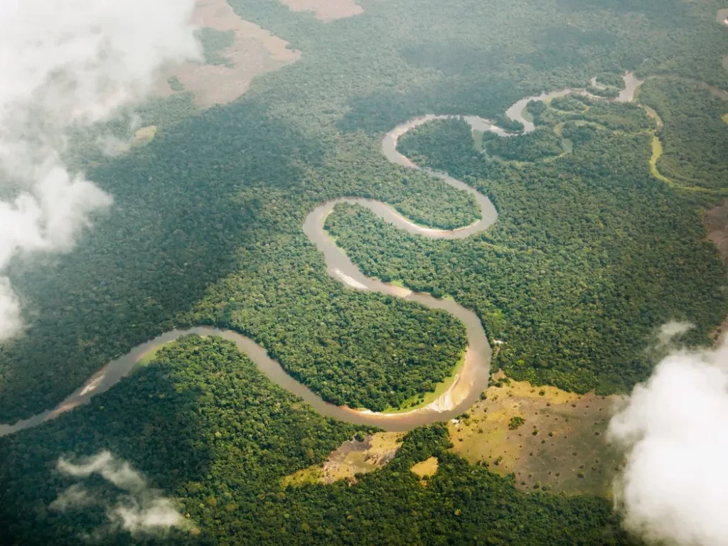
The Congo River! Second longest river in the world to the Nile, Second largest river by discharge to the Amazon, Second largest river drainage basin area to the Amazon. Second largest rainforest to…the Amazon. You might think that the Congo river is the perennial silver medalist. You might think that there are more interesting rivers around the world, but don’t pity this mighty river. It’s a fascinating body of water full of stories and meaning. It plays a crucial part in the economies and cultures of the regions it runs through, it’s a vital part of the natural world of a great swathe of the African continent. If you’re looking for a record that sets the Congo River apart, then look down. The Congo River is staggeringly deep, it’s by far the deepest river in the world with some very specific geological factors that force the river deep into the earth. Let’s explore! Formation and History The Congo River’s formation is a result of tectonic activities causing the uplift of the East African Rift. Here, the African plate has spent the last 25 million years slowly tearing itself in two, the newly formed Nubian plate and Somali plate are sliding apart at around 6-7mm per year. The area is littered with other features of this tectonic activity such as Lake Tanganyika, mount Kilimanjaro, and the Danakil Depression, each of which are fascinating in their own right. The Congo River basin is estimated to have formed over 1.5 million years ago during the Pleistocene epoch when tectonic activity caused the landscape to shift and create the vast drainage basin we see today. Source and Mouth The most upstream source of the Congo river is the Chambeshi river. It begins its journey to the Atlantic ocean high up on the Zambian Plateau at an elevation of 1,760m (5,774 feet) above sea level and just 430 miles from the Indian Ocean. The Chambeshi flows through the Bangweulu swamps where it merges with the Luapula River. The Luapula River flows in a northeastern direction before joining the Lualaba, which is sometimes considered the main upper course of the Congo as it contributes by far the greatest share of water by volume at this point of the river’s journey. By Kmusser – Own work, Elevation data from SRTM, drainage basin from GTOPO, all other features from Natural Earth, CC BY-SA 4.0, https://commons.wikimedia.org/w/index.php?curid=75858826 The river charts a course due north for the next 1,600km (1,000 miles) through the heart of the Democratic Republic of Congo. In this section of the river, you may think that it will simply run its course all the way to the ocean in a more or less straight line, much like the Nile. However, at the town of Kisangani, almost exactly on the equator, it turns eastward and finally changes its name to The Congo River. From here it takes a giant southwestbound arc across the north of the Democratic Republic of Congo. For roughly 1,000km of this journey the river forms the (somewhat disputed) border between the Democratic Republic of Congo and the Republic of Congo, eventually bisecting the two capitals of Brasserville and Kinshasa. These two cities, formerly the capital cities of the states of French and Belgian Congo, hold the record for the closest capital cities at just one mile apart (we’re not counting Rome and the Vatican!). The river eventually empties into the Atlantic Ocean at the delightfully named Port of Banana on the border of the Democratic Republic of Congo and Angola. Unlike many other rivers of comparable scale, the Congo River doesnt really have much of a mouth to speak of. Look at the Amazon, Mississippi or Nile and you will notice that their mouths spread into broad outflows often hundreds of kilometers across and filled with multiple streams. The Congo River, on the other hand, is a little over 5 kilometers at the point it discharges into the ocean. Drainage Basin The drainage basin of the Congo River is penned in by various geographical features. To the north is the Central African Republic, where the watershed takes rivers north and east into the gulf of Guinea or the endorheic basin of Lake Chad. To the northeast, rivers flow mostly into the Nile. To the east, the great Rift Valley forms an impenetrable obstacle, all rivers east of the great rift, such as the Tana in Kenya, the Pagnani in Tanzania eventually find their way into the Indian ocean. To the south a series of mountain ranges, plateaus and highlands in Zambia and Angola force the Congo River northbound. To the northeast, the rivers of Gabon and Cameroon flow directly into the Atlantic Ocean, Gulf of Guinea, or form tributaries of the Niger river. All in all, this gives the Congo drains an impressive 3,730,881 square kilometers of area in the center of Africa. This is the second largest drainage basin of any river in the world.. At Kinshasa and Brazerville, the flow rate ranges from a high of 65,000 to a low of 21,000 cubic meters. It is estimated (but not confirmed) that a series of floods in 1962 caused flow rates in excess of 73,000 cubic meters which is thought to be the highest flow rate ever down the river. Widest and Deepest Points The Congo River is unusual in many ways. It is broadly split into three sections, the upper, mid and lower Congo. The upper Congo consists of all tributaries upstream of the town of Kisangani. As with many river systems, the upper Congo River is interrupted at regular intervals with waterfalls and rapids, including the Boyoma falls at Kisangani. These waterfalls contribute to generally challenging navigability and make the upper Congo unusable for all other than local traffic. From Kisangani to the Malebo pool is considered the middle Congo. As it meanders down through the Central African republic, it splits and reforms in channels, side channels and branches, sometimes forming islands many miles across. Many of these islands have