Asia

The Imago Mundi

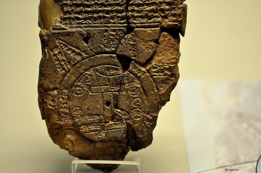
The Babylonian World Map, also known as the Imago Mundi, is one of the oldest known representations of our world. This ancient map offers a fascinating glimpse into the geographical knowledge and worldview of the Babylonians over two and a half millennia ago as well as their expertise as craftsmen. In this article, we will look at the discovery of the map, its creation, materials, authorship, similar maps, what it depicts, its accuracies and inaccuracies, its impact and legacy, and its current location. Discovery and Background The Map was discovered during archaeological excavations in the ruins of the city of Sippar in the late 19th century. Sippar was one of the oldest cities in Mesopotamia with origins dating back as far as 2900 BC. It was found on the eastern banks of the Euphrates close to Baghdad in modern day Iraq. Sippar was a significant urban center with a population of up to 40,000 inhabitants, comparable in size with other cities such as Ur and Uruk. It was known for its temple dedicated to the sun god Shamash. Given its location on the Euphrates, it was also an important trading outpost.  By MapMaster – Own work, CC BY-SA 4.0, https://commons.wikimedia.org/w/index.php?curid=3578442 Creation and Materials The exact date of the map’s creation is not well-documented, but it has been estimated at no earlier than the 9th century BC. It was part of a series of finds that provided substantial insights into ancient Mesopotamian civilization. The map was created during the Neo-Babylonian period. It is inscribed on a clay tablet using the now extinct Cuneiform Akkadian language, a writing system developed in the city of Akkad, and used across Mesopotamian. The tablet measures approximately 12.2 cm by 8.2 cm, with a generally better preserved upper half, the lower extremities having been lost.  The clay tablet was likely produced by a Babylonian scribe. Although the identity of the scribe remains unknown, there are some clues in the text contained on the front of the tablet. This map is part of a larger tradition of Mesopotamian cartography and geographical texts, reflecting the intellectual and scholarly pursuits of the time. The use of clay tablets was common in Mesopotamia due to the abundance of clay in the region and the durability of baked tablets. What does the map actually depict? By Osama Shukir Muhammed Amin FRCP(Glasg) – Own work, CC BY-SA 4.0, https://commons.wikimedia.org/w/index.php?curid=42131230 The map is divided into three sections. On the front, the pictorial representation, the map itself, is found on the lower two thirds of the front of the tablet. The upper third is text. On the rear of the tablet is also text. The structure and information of each section differs greatly, implying that the three sections may have been compiled from three different and possibly unrelated original sources. The first thing to notice of the map section are the two circles that cover more than half of the map portion. They are labeled ‘Maratum’ which literally translates as ‘Bitter River’. It is thought that this represents the Persian Gulf. The label refers to the salt sea. The Persian gulf was over 500km from Sippar.  Inside the circles, there are 7 additional smaller circles, which are thought to represent 7 cities, with Babylon being represented in the center at the top. The parallel lines at the bottom of the map represent marshland, which could be the current day Iraq Central marshes, Hammar marshes or Hawizeh marshes. A line in the north east corner of the map appears to be the modern day Zargos Mountain range, which runs from south east Turkey, down the eastern border of Iraq and onwards into western Iran as far south as the strait of Hormuz. All of the labeling and annotation on the inside of the circles is in Cuneiform. Seven or eight triangular sections outside the water circle represent named “regions” (nagu). The descriptions for five of them have survived. The map indicates features spread across much of eastern Iraq, an area of many hundreds of thousands of square kilometers.  The text above the map describes the creation of the land and sea by Marduk, the patron saint of Babylon. It is written that he parted the primeval ocean, called Tiamat, thus raising dry land.  The next few lines refer to at least 15 animals, the Mountain Goat, Gazelle, Lion, Wolf, Monkey (and female Monkey), Ostrich, Cat and Chameleon. Other than the Cat, none of the animals listed were to be found in ancient mesopotamia. The last two lines of the text refer to three legendary heroes: Utnapištim (the hero of the Flood), Sargon (ruler of Akkad), and Nur-Dagan the King of Buršaḫanda (opponent of Sargon). The back side contains at least 29 lines of text and seems to be a description of the nagu, or regions of ancient Mesopotamia. It is assumed that the nagu listed on the rear are the same nagu as depicted on the front. After an introduction, possibly explaining how to identify the first nagu, the pattern for the remaining descriptions is to list the nagu by number, and state the distance in leagues that one must travel to get there from the previous nagu. The distances listed on the rear do not seem to correspond to any scale depicted on the front. This could be because such scale drawings were not helpful when journeys were measured in days or weeks. It could more simply be that the rear of the tablet is referring to a different set of nagu than those represented on the front of the map.  A short description is given for each of the eight nagu, but those of the first, second, and sixth are too damaged to read. The fifth nagu has the longest description, but this too is damaged and partially unreadable.  There are some rather strange pieces of information that the author though to include, such as: ‘The third nagu may be a barren desert, impassable even for birds: A winged bird cannot safely

The Imago Mundi Read More »

The Great Migration

Imagine a Europe that was centrally controlled. Politicians operated in a single party and controlled the economy, infrastructure, culture and lifestyles of its citizens. One year, they decide that every man, woman and child in western Europe should migrate to a different country. Every person in Germany, the UK, France, Italy, Spain, Poland, Romania, the Netherlands, Belgium, Sweden, Czech Republic, Greece, Portugal, Hungary, Austria, Switzerland, Bulgaria, Denmark, Slovakia, Ireland and Croatia is encouraged to move to a new country, say Latvia. On top of this, the infrastructure in Latvia is non-existent, mega-cities will need to be built from scratch, entire societies will need to be brought into existence, and those new societies will eradicate the rural lifestyle that existed previously. What’s more, we have just 40 years to complete this mammoth task. Imagine the utter chaos that this would cause. Imagine the social strife, the loss of community and traditions, the re-ordering of an entire society from sleepy rural to high tech urban. This very change has occurred in living memory. Of all the population movements in world history, none can match the scale of rural to urban migration in China. It is the single most massive demographic shift in all of human history. This mass movement of people from the countryside to cities has profoundly reshaped China’s social, economic, and political landscapes, affecting everything from labor markets to environmental sustainability. It has seen the growth of urban centers of global size virtually unheard of outside of China. Firing the starting gun The large-scale migration from rural to urban areas in China began in the late 1970s, coinciding with the economic reforms initiated by Deng Xiaoping. These reforms, collectively known as the “Open Door Policy,” aimed to modernize China’s economy by introducing market-oriented principles and welcoming foreign investment. The result was an economic boom that created the marvel that is modern day Chinese manufacturing. The rate of migration has been staggering. Between 1979 and 2018, more than 500 million people moved from rural areas to cities, the majority of this migration has been from the rural north and west towards the now urban population centers of east and south China. The annual migration rate has varied over the decades, peaking during periods of rapid economic growth and declining slightly during economic downturns. As of 2020, it is estimated that over 60% of China’s population lives in urban areas, an increase from just 18% in 1978 Traditional China China has history and traditions that stretch back thousands of years and contain a richness to rival any other nation. It is responsible for some of the greatest feats of engineering. The 22,000 kilometers of the Great Wall of China, the Terracotta Army, the Forbidden City. Before the onset of mass migration, China was predominantly a rural society. The majority of the population lived in small villages and towns, engaging in agriculture and related activities.  The traditional demographics were characterized by large extended families living in close-knit communities with limited access to modern amenities and infrastructure. Its rural population was responsible for some of the invention of technologies such as paper, silk, gunpowder, decimal mathematics, and the game of chess. It produced some of the world’s first literature and art, architecture and sculpture. Its culture had persevered through wars and invasions, famines and natural disasters. Its rural population was doing just fine. Disaster Strikes The Chinese government’s policies have been virtually entirely responsible for the migration. Before the drive for urbanization, the “hukou” system, a household registration system, traditionally restricted rural inhabitants’ ability to move freely through the country. Its aim was to tie its rural farmers to the land that they worked and ensure a steady supply of food and commodity goods that could be traded, and it sort of worked. China kept on keeping on. All of that came to a crashing and tragic end in the late 50s. Back to back years in 1958, ‘59 and ‘60 saw a catastrophic fall off in crop yields. The resultant famine saw the death of as many as 60 million people through starvation. Something needed to change.  However, reforms to the Hukou system were only gradual and restrictions were not granted lightly, allowing more people to seek employment and better living conditions in cities took a while to establish itself. Government initiatives such as the “Go West” strategy and the development of Special Economic Zones (SEZs) encouraged migration by creating job opportunities and improving infrastructure in urban areas. However, even this began as a cautious policy. From 1979 to 1983, farmers were allowed to migrate to urban areas on the condition that they provide their own food. It wasn’t until 1984 when this restriction was lifted that the floodgates really opened and by 1992 the migration was actively encouraged by the government.  Additionally, policies aimed at reducing rural poverty and modernizing agriculture have allowed for fewer people to produce the requisite food requirements and freeing many rural residents to seek better prospects in cities.  Chinese Mega Cities There is a great deal of debate regarding how to measure city sizes with no consensus. If measured by the ‘city proper’ designation (all people living within the city limits) then China occupies 6 of the 10 largest cities on earth. Chongqing, Shanghai, Beijing, Chengdu, Guangzhou and Shenzhen, all of which contain more than 17 million people each. There are a staggering 105 cities in China with more than 1 million residents. lity The migration of millions of people to urban areas has been both a cause and a consequence of China’s rapid economic growth. Urban centers have become the engines of economic development, attracting investment and fostering innovation. The influx of labor has fueled the manufacturing and service sectors, contributing to China’s emergence as a global economic powerhouse. Outsourcing of manufacturing from western countries has become so standard that the ‘made in china’ label on goods has become ubiquitous.  The economic opportunities in cities have significantly improved the living standards of many migrants, allowing

The Great Migration Read More »